
Under Construction
...Thanks for visiting McArthurRanch.org
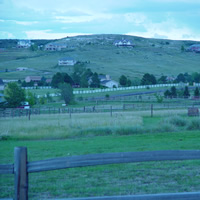
The ranch was originally homesteaded by Edith and Mark D. McArthur in 1919. The McArthurs had come from the mid-west by covered wagon and lived in Littleton at the time they homesteaded the ranch.
Mr. McArthur was a mining engineer and his work sometimes took him out of the state
for long periods of time. During this time, Mrs. McArthur operated the
livestock ranch raising both cattle and horses. The area in which Falcon Homes
now has developed, was owned by the Finns. The sod house on the Falcon Homes
property was a part of that ranch. The McArthurs leased that property
(approximately 320 acres) for grazing. They also leased an additional 640 acres
which was the school section immediately north of McArthur Ranch Third Filing.
That section now contains Lone Tree Estates, the Carriage Club, the U.S. Homes
Development, and the South gate Water Storage Facility.
Ed Smith and William Myrick bought the ranch from Mrs. McArthur in 1969. Mr. McArthur had died in the early 60s, and Mrs. McArthur then in her 80s, did not wish to continue ranching. In 1970, McArthur First Filing, composed of 14 tracts, was developed. Smith and Myrick
continued to ranch the Finn property, the school section, and the remainder of McArthur Ranch. Mrs. McArthur had sold a 5-acretract from the property prior to 1969, to Mr. and Mrs. Harold Webster .This is presently the Seagren/Duggan property. Mrs. McArthur had also sold 100 acres (now Highland View Estates) to the Robinson Brick Company. Robinson continued to mine brick clay from that acreage until the late 1970s when the brick clay deposit was depleted.
The original 14 tracts in the First Filing were sold for $8,000 each. The first house that was completed was by Dan and Sara Gohr on tract 12. At that time there were three homes on the ranch: the Myrick residence; the Webster residence; and the Gohr residence. The sales in the First Filing helped make the payments to the bank and to Mrs. McArthur which were obtained for the acquisition of the property .In 1972, the 17 lots in the Second Filing of McArthur Ranch were completed. The prices on these tracts ranged from $12,500 to $17,500 each. Proceeds from the sale of these tracts helped pay for the development costs, the gravel roads, the underground utilities, the payments to the bank, and Mrs. McArthur. In 1974, the Third Filing was completed and the existing gravel roadways and underground utilities were constructed. A real estate recession began in 1975. Very few lots were sold until approximately 1977 and 1978. The Third Filing lots were sold from $17,500 to $26,500.
In 1972, Ed Smith decided to sell his one-half interest in the partnership in order to open the Denver Automobile Auction, a business in which he was previously engaged. Another bank loan was arranged to allow Smith to take his 50% interest in the property in cash. Had it not been for the bank's willingness to renew the loans and adding the interest to the principle until 1978, the property could have gone into foreclosure. The McArthur note was always paid as agreed.
In 1972, William Myrick formed the McArthur Ranch Recreation District, which included the entire 695 acres of McArthur Ranch. At that time, the Third Filing was being planned and the balance of the ranch was reserved for "future development". The county imposed a requirement (which was established sometime after the development of McArthur Ranch First Filing) that 6% of newly zoned property should be given to the county for school or park purposes. The county agreed that some of the 6% requirement could be satisfied by Myrick making a property gift to the Recreation District as opposed to the county. The District directors and Myrick worked out a plan, agreed upon by the county, wherein the county would accept a gift from Myrick for the two lots on the southeast corner of Valley and Oneida, and Myrick would give a 5-acre tract to the Recreation District to satisfy the immediate requirements from the first three filings.
It was further agreed that if a 15-acre tract (the Montessori School tract) and a 10-acre tract east of tract 38 on the cul-de-sac at the end of Oneida (between the two cliffs) was gifted by Myrick to the Recreation District, the county would allow this donation to satisfy the 6% public acreage requirement for the future development of the property. This gift was to be made at the time the Recreation District qualified for matching improvement funds, equal to the value of the property.
The 5-acre tract, which contains the shelter house and tennis courts, was obtained by the Recreation District as a gift from Mr. Myrick pursuant to that agreement. The government program providing the matching funds was discontinued and the Recreation District necessarily abandoned its plans to improve the property. Mr. Myrick continued to leave the property open and available to be gifted to the Recreation District when the balance of the property was approved for development. Mr. Myrick has retained tract 38, which adjoins the 10-acre parcel between the cliffs, which is a part of the Third Filing. Until Tract 38 is sold, or built upon, the opportunity remained to have an approximate 26-acre park between the unique cliffs on the east and the west, and at the south end of Oneida Street at the cul-de-sac. Based upon the option price with Montessori School and recent lot sales, Tract 38 and the 10-acre tract between the cliffs have a present value between $300,000 and $400,000. The two tracts previously given to the county (Tracts 43 and 44) now owned by the Recreation District, have a value of approximately $300,000 to $350,000. Preserving a 26-acre park or open parcel at that location will tend to increase the value of each individual lot in McArthur Ranch Filings I, II and III.
The Phipps Ranch, now owned by Mission Viejo, was a 22,000-acre ranch acquired by Lawrence Phipps, Jr. throughout the years beginning in 1939. The Phipps Ranch was sold to Mission Viejo in 1986. 8,000 acres are planned to be left as "open space"; and 14,000 have been utilized as a planned city development (in Highlands Ranch) by the Mission Viejo company.
Rampart Range was originally planned and zoned in 1973. That project is presently owned by Coventry Development, an international development company, with representatives in New York City. The development guide for that property was revised and approved by the county in 1985. At that time, the development on the bluffs east of McArthur and west of 1-25 owned by Rampart, were changed in density from a 2.6 units per acre to 1 unit per acre. Under its present zoning and approved development guide, there are 261 approved units which adjoin McArthur
Ranch on the south and east. (See attached Rampart Range development plan).
Rampart Range has an easement, the location of which may be designated by Mr. Myrick through the 142 acres on the bluffs east of McArthur Ranch Third Filing and Highlands View Estates. Mr. Myrick has an easement through the 80 acres adjacent to the 142 acres in McArthur Ranch and the approximate 35 acres above Tracts 46, 47, 73, 74, and 75. This easement will allow the development above the cliffs on the south side of McArthur Ranch Third Filing to be served by Heather Drive in Surrey Ridge.
In 1987, the Finn property east and north of McArthur Ranch, containing
approximately 320 acres, was zoned for 1,000 units. This is the Falcon Homes property.
The area now known as Highlands View Estates was originally zoned in the early 1980s for 2-1/2 acre parcels, or 25 units, on the lOO acres which was originally the Robinson Clay Mine. In 1995, that property was sold by the RTC to Moskowitz, who agreed to down-zone it to 10 parcels on the lOO acres if the county would not require him to pave the roads or to comply with other development standards.
In 1992, Myrick obtained an option from the State of Colorado to purchase the remaining 300 acres (U.S. Homes property) north of the ranch and proposed a change in the master plan to allow 1,012 units to be built on the entire 567 acres which would include the remainder of McArthur Ranch. This plan included 116 units to be built on the remainder of the ranch with 30% of the 567 acres being reserved as open space. This plan contemplated bringing water and sewer through Southgate Water District to the ranch.
In the late 1970s, the north half of the state land section was sold and was developed as the Lone Tree Estates. In 1995, the balance of that property which adjoins McArthur Ranch to the north, was sold to U.S. Homes, who obtained a change in the master plan and have acquired ER zoning ( I unit per acre) and apparently have had a plan approved which will allow them to leave approximately 200 acres open and build approximately 320 units on the lOO acres on the west side of that property.
As you are aware, Quebec is to be extended to the road which leads to Castle Pines North. A high school is to be built west of McArthur Ranch, south of McArthur Ranch Road and east of Daniels Park Road. These approved plans will likely greatly increase the traffic within the ranch unless a plan can now be developed to protect and limit the amount of development which will eventually utilize the ranch roadways. Although 56 additional residents will in fact increase the traffic in a minor way, development and platting plan can have the maximum effect of discouraging outside users. If there is an interest by the residents to limit the use of McArthur Ranch Road through platting and design, that will necessarily have to be done prior to the platting of Rampart Range.
At the present time, without the necessity of county approval, 8 additional residences could be built. Dividing the 142 acres into 35-acre tracts would leave them available for an owner of 35 acres to later cooperate with Rampart Range, and/or others, to increase the density and utilize the McArthur public roadways. Larger tracts will be subject to later development pressures. These future pressures may be avoided or alleviated through a final development plan approved at this time.
The Douglas County master plan, without amendment, allows for maximum zoning of 112 units to be consistent with that plan. The present McArthur plan for 56 units with 50% open space does not require an amendment to the Master Plan. The Master Plan allows density of 1 unit for each 2-1/2 acres (20% bonus if 50% open) in the non-urban area. The maximum density requires either a public water system and/or a public sewer system.